“The new black” is a term derived straight from fashion shorthand. For most of the 20th century, black was the default: timeless, slimming, elegant, and, crucially, always appropriate. Coco Chanel famously cemented this idea in the 1920s with the “little black dress.” Consequently, black became the safe baseline against which all other trends rotated.
In the Earth observation industry, Landsat was the black. For decades, Landsat defined the baseline for Earth observation data. During this period, multispectral imaging effectively meant:
- A fixed set of broad spectral bands.
- Long-term continuity and rigorous calibration.
- General-purpose use across agriculture, land use, water, and climate.
Landsat was not merely a mission; it was the reference model for how EO data was designed, distributed, and interpreted. However, we are now seeing a shift in the baseline for satellite mapping. These new demands are resulting in quiet but significant changes.
Hyperspectral missions that shaped Europe
Over the last decade, two major missions have dominated the European hyperspectral scene. While Europe’s leadership in hyperspectral Earth observation historically lagged behind early pioneers (e.g. NASA’s Hyperion), the launch of PRISMA (2019) and EnMAP (2022) finally closed this strategic capability gap. Through these missions, Europe positioned itself as a global leader in high-fidelity hyperspectral monitoring.
Why these missions mattered:
| Reason | How PRISMA Contributes | How EnMAP Contributes |
| European EO leadership | First major Italian hyperspectral satellite | Germany’s flagship hyperspectral mission |
| Environmental/climate intelligence | Wide applications: agriculture, forestry, water, and hazards | Global VNIR–SWIR monitoring of land & atmosphere |
| Technological autonomy | Fully Italy-funded & Italy-built system | DLR-developed national hyperspectral capability |
| Economic/industrial benefits | Supports agriculture, mining, and ecosystems | Supports environmental, land, and atmospheric science |
| Scientific research | High-quality hyperspectral datasets | Pathfinding for future missions & research |
What quietly changed
Hyperspectral imaging is not a new concept; it has existed for years. However, it was previously unpopular in the commercial world because it was perceived as bulky, power-hungry, and, most importantly, pricy.
Eventually, four things converged to change the market:
- The miniaturisation of optics and detectors, alongside new spectral filter processing.
- The development of onboard processing and smart compression.
- The emergence of software-defined instrument architectures.
- A significant reduction in overall costs.
The "new black" move
In the rapidly transforming space industry, hyperspectral Earth observation has emerged as a powerful next-generation sensing technology. What makes it truly revolutionary is how well it aligns with the growing need for autonomous, disconnected payload operations.
Landsat era baseline | Hyperspectral “new black” |
Fixed band set | Dynamic selectable bands |
One-size-fits-all | Task-optimised planet imagery |
Downlink everything | Detect and filter onboard |
Pixels first | Spectral signatures first |
Here’s why hyperspectral EO is positioned to become the next major leap in satellite payload capability:
1. Hyperspectral sensors reveal what multispectral systems cannot
Hyperspectral payloads capture hundreds of narrow, contiguous spectral bands. This enables the identification of subtle material characteristics and chemical compositions that are invisible to a traditional multispectral satellite camera. This ability to distinguish materials with laboratory-level precision from orbit makes hyperspectral imaging ideal for autonomous applications that require real-time decision-making.
2. Onboard processing enables real-time insights without ground contact
The shift toward edge processing in space is accelerating, with satellites increasingly performing complex data analytics onboard before transmitting results. In bandwidth-limited scenarios, this is a game-changing capability, as satellites can now perform science onboard rather than simply acting as data collectors.
3. Hyperspectral EO aligns perfectly with autonomous, disconnected operations
Disconnected autonomous operations require sensors that:
- Collect rich, high-density data.
- Analyse and classify data onboard.
- Detect anomalies or emerging events automatically.
- Trigger responses or task future observations.
- Operate efficiently with minimal bandwidth.
Hyperspectral sensors excel across all these dimensions. Because they capture material-level information, hyperspectral imagers enable onboard AI to classify vegetation stress, detect mineral signatures, identify pollution events, or recognise man-made structures more reliably than lower-resolution systems.
Furthermore, high spectral fidelity improves the performance of onboard machine-learning models. This enables satellites to autonomously categorise targets or flag anomalies-capabilities highlighted in research on UAV and satellite hyperspectral analytics. This underscores their value for precision agriculture, mineral exploration, and environmental monitoring when combined with modern AI techniques.
Essentially, hyperspectral sensors give autonomous payloads “more to think with.”
4. Miniaturisation is making hyperspectral sensors more suitable for small, autonomous satellites
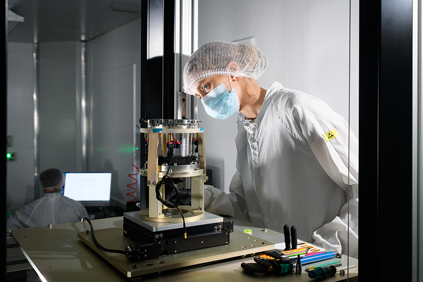
Historically, hyperspectral instruments were large, heavy, and power-hungry. However, breakthroughs such as the ESA-funded RAINBOW project demonstrate that compact filter-on-chip hyperspectral sensors can now fit into small satellite platforms while still capturing 30+ spectral channels from 400–1700 nm.
This miniaturisation:
- Opens hyperspectral imaging to CubeSats.
- Reduces cost and improves launch opportunities.
- Allows constellations to operate with distributed autonomy.
- Enables edge computing architectures on smaller platforms.
As a result, even small, disconnected satellites can now carry advanced hyperspectral payloads and run AI-driven onboard analytics. Simera Sense’s HyperScape100, which can capture 32 bands from 400 options, is another prime example of this evolution.
5. Hyperspectral data supports critical use cases that benefit most from autonomy
Many high-value EO applications demand immediate environmental or situational awareness through diverse spectral signatures and planet imagery:
- Agriculture & food security: early detection of crop stress, water deficiency, disease, and nutrient imbalance.
- Disaster response & environmental monitoring: hyperspectral imaging can identify chemical spills, burned areas, flood contamination, and air quality anomalies faster and more accurately than multispectral systems. When processed onboard, satellites can autonomously flag events in near-real time.
- Security & defence: hyperspectral sensors detect concealed installations by analysing material signatures; something traditional Earth observation satellite images cannot match.
- Mineral exploration & surface composition mapping: hyperspectral satellites offer global mapping of chemical composition, with onboard analytics enabling efficient autonomous mineral prospecting from orbit.
These are all domains where waiting for ground-based processing introduces unacceptable delays; further strengthening the value of autonomous, disconnected hyperspectral payloads.
6. Hyperspectral + autonomous operations = a foundational technology shift
Taken together, these developments show that hyperspectral EO is not merely an incremental improvement; it represents a fundamental evolution in how satellites sense and respond to the world. The convergence includes:
- Richer spectral data (material-level insight)
- Smaller, more affordable sensors (filter-on-chip technologies)
- Onboard AI and edge computing (real-time decision-making)
- Reduced reliance on ground connectivity
- Applications that demand autonomy
This combination positions hyperspectral EO as the ideal payload technology for the next generation of smart, autonomous satellite systems.
The HyperScape100: a game changer
Simera Sense’s HyperScape100 is pushing the boundaries of space-based hyperspectral imaging by delivering unprecedented performance in a CubeSat-class form factor. It achieves a 4.75 m GSD, a 19.4 km swath, and up to 32 user-selectable VNIR bands, packaged in an extremely compact 1.5U payload, enabling high-fidelity hyperspectral sensing that has traditionally been limited to much larger and more expensive satellite platforms. Its advanced optical design, high spectral sampling (1 nm increments), robust onboard storage, and optional onboard image processing make it one of the most capable commercial hyperspectral imagers available today: especially remarkable given its size and power constraints. This combination of high spectral and spatial resolution with miniaturisation is why HyperScape100 is recognised as a major leap forward for next-generation Earth observation missions.
Wyvern provides a real-world example of how HyperScape100 is enabling a new class of commercial hyperspectral missions. The company’s Dragonette satellite constellation, described as delivering the highest-resolution commercial hyperspectral imagery from low Earth orbit, uses Simera Sense’s HyperScape100 as the core satellite camera, forming the backbone of Wyvern’s high-resolution data offering. This instrument allows Wyvern to collect high-quality hyperspectral data daily, supporting applications across agriculture, environment, energy, and security markets.
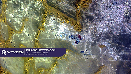
Includes imagery from Dragonette-001, 2024, Wyvern. All rights reserved.
Conclusion
Hyperspectral Earth observation is becoming the next big thing for satellite payloads, particularly those operating autonomously and in disconnected environments, because it combines unparalleled data richness with the ability to process and act on that data directly in orbit.
As hyperspectral systems become smaller, cheaper, and more deeply integrated with onboard AI, they unlock new mission concepts and enable satellites to evolve from data collectors into autonomous agents: monitoring, classifying, and responding to events on Earth with minimal human intervention.