Precision Forestry: 17 Applications Using Earth Observation Data

Advanced Earth Observation applications are finding its way into forest management as part of the Precision Forestry transformation process.
The dawn of a new era in forest management
At its best forest management is a balancing act between demand and supply. With the ever-increasing population maintaining a sustainable forest ecosystem is a huge challenge. The word sustainable in forestry brings a range of factors into account, including biodiversity, tree health, and resilience against disease and fire.
Forestry is not alone in maintaining a sustainable environment and juggling between demand and supply. Over the last couple of decades, the concept of precision agriculture produced great value in managing products from the land to the table in a sustainable way.
Even still today, decisions in forestry are primarily made through human observation. In many cases, it entails the manual interpretation of aerial photography. But we do see the transition to more advanced remote sensing technologies, including airborne laser scanning, terrestrial laser scanning, digital aerial photography, and satellite optical earth observation.
Precision Forestry: A tool for forest management

A June 2018 report by Mckinsey on Precision Forestry describes the traditional approach to forest management as highly “manual and analogue processes”. The report sees the precision forestry as a system with “digital data capture and planning, granular management prescriptions, and tight operational control”.
The question is, can remote sensing technologies do the same for forestry as it did for agriculture. The idea is based on optimising the whole process from seedling to the end-user through an integrated but involved decision-making process. This process requires a complex set of information and needs to be accurate, spatially detailed, up to date, and must characterise the composition, structure and productivity of a forest.
The technology landscape using Earth Observation data
The following list provides some detail on the Earth Observation applications already employed in Precision Forestry. An indication of the required Earth Observation parameters is also provided. The parameters include Ground Sampling Distance, number of spectral bands, the spectral range and frequency of imagery required.
1. Land Cover Analysis
Quantifying change in land cover is key to the management of forests and is an integral part of precision forestry. Land Cover is defined as the biological cover observed on the land and does require specific analysis tools to identify, classify and quantify.
Recommended Earth Observation parameters:
| GSD: 5m to 30m | 4 to 7 Bands | 450 nm to 900 nm | Weekly to Monthly |

2. Land Use Change Detection
Forest land use is a function of the social and economic purpose for which the land is managed and requires a specific dataset and tools. Precision forestry is assisting in the sustainable land use of forests by classifying information with situational context obtained through various digital tools.
Recommended Earth Observation parameters:
| GSD: 5m to 30m | 4 to 7 Bands | 450 nm to 900 nm | Monthly to Quarterly |
3. Distribution of Timber Resources
Timber resources form the backbone of the forest industry and require optimal management processes. Various types of timber are used in multiple industries and provide value from an environmental, social, and economic perspective. Some regions have more timber resources than others, making the knowledge of the specific distribution so much more important. Forest Management is using various Earth Observation tools to identify and classify timber resources over a larger area.
Recommended Earth Observation parameters:
| GSD: 5m to 30m | 4 to 5 Bands | 450 nm to 900 nm | Quarterly to Annually |
4. Determination of Carbon Stock
Forests are essential for carbon storage. Reducing emissions from deforestation and forest degradation and the role of conservation, sustainable management of forests and enhancement of forest carbon stocks in developing countries (REDD+) has gained significant attention in international climate negotiations. REDD+ programs require reliable, accurate, and cost-effective methods for measurement and monitoring of forest carbon storage.
Recommended Earth Observation parameters:
| GSD: 5m to 30m | 4 to 5 Bands | 450 nm to 900 nm | Quarterly to Annually |

5. Hydrology Management Models
Modelling the land surface water balance is becoming crucial in an environment where climate change is a reality. Forest management is using Earth Observation data to model precipitation, changes in soil moisture, runoff, radiation components, sensible heat flux, latent heat flux, soil heat flux, changes in energy storage in biomass, primary production and monitoring the extent, type and density of forests.
Recommended Earth Observation parameters:
| GSD: 10m to 30m | 4 to 5 Bands | 450 nm to 1,700 nm | Quarterly to Annually |
6. Automated Forest Inventories
Forest inventory and management requirements are changing rapidly due to the increase in economic, environmental, and social needs. Remote sensing technologies are addressing these escalating information needs and knowledge models in an automated way.
Recommended Earth Observation parameters:
| GSD: 0.5m to 2m | 3 to 4 Bands | 450 nm to 900 nm | Monthly to Quarterly |
7. Monitoring of Logging Impact
The primary cause of deforestation is logging activities. Forest logging results in a loss of biodiversity and has a direct impact on plant and animal life. Forestry logging is an ongoing activity which should be observed on a frequent basis.
Recommended Earth Observation parameters:
| GSD: 2m to 20m | 3 to 4 Bands | 450 nm to 900 nm | Weekly to Monthly |

8. Detection of Illegal Logging
The destruction of forests due to illegal logging is well documented but extremely difficult to detect and monitor and is largely poverty-driven. Illegal logging produces significant canopy gaps, making it easy to detect with remote sensing technologies.
Recommended Earth Observation parameters:| GSD: 2m to 20m | 3 to 4 Bands | 450 nm to 900 nm | Weekly to Monthly |
9. Determination of Areas with Plant Stress
Plant stress is an indication of an underlying problem. Remote sensing analysts are using various vegetation index models for the early detection of plant stress as part. This same method is used in precision forestry to coordinate response and minimise the impact.
Recommended Earth Observation parameters:| GSD: 1m to 10m | 5 to 7 Bands | 450 nm to 900 nm | Weekly to Monthly |
10. Stratification of Productivity Zones
The primary goal of forest managers is to maximise forest productivity. To do this, managers need access information to determine the productivity of the land and the related effects of land management practices on forest productivity. Given the large areas to manage, remote sensing tools are well suited to provide relevant information and long-term knowledge of specific areas. With this knowledge, accurate productivity predictions are possible.
Recommended Earth Observation parameters:
| GSD: 1m to 10m | 3 to 5 Bands | 450 nm to 900 nm | Weekly to Monthly |

11. Fire Threat and Fire Detection
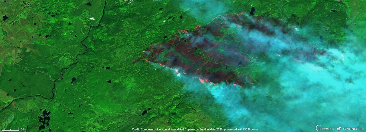
As experienced over the last couple of years, forest fires are a significant threat to the environment at large, causing disaster beyond measure and description. Remote sensing has become a primary data source for fire danger rating prediction, fuel and fire mapping, fire monitoring, and fire ecology research.
Recommended Earth Observation parameters:
| GSD: 5m to 30m | 4 to 5 Bands | 450 nm to 900 nm | Daily to Weekly |
12. Pest and Disease Spread
Forest insect pest and disease is one of the main factors influencing forest health. Detecting and monitoring its outbreaks, and estimating the area affected, are therefore crucial for both forest managers and forest ecologists. Regular images at relatively high resolution in multiple spectral bands enable the monitoring of defoliation and predict diseases in the trees.
Recommended Earth Observation parameters:| GSD: 1m to 10m | 5 to 7 Bands | 450 nm to 900 nm | Weekly to Monthly |
13. Development of Planning Models
Forests usually cover vast areas inaccessible to humans, making the development of accurate models of the area under management extremely difficult. Forest Management is using Earth Observation data is used to augment current models, by identifying and classifying specific forest areas and predicting productivity levels as well as areas of particular interest.
Recommended Earth Observation parameters:| GSD: 1m to 10m | 5 to 7 Bands | 450 nm to 900 nm | Weekly to Monthly |
14. Monitoring of Reforestation
Forest regeneration is of utmost importance during the current climate-changing times, especially in areas of low reforestation potential. Estimating the success of large-scale reforestation is challenging in remote areas. Forest Management is using Earth Observation data to monitor vegetation water content and photosynthetic activity to quantify biomass activity.
Recommended Earth Observation parameters:
| GSD: 2m to 20m | 5 to 7 Bands | 450 nm to 900 nm | Quarterly to Annually |
15. Calculation of Leaf Area Index
Leaf Area Index (LAI) is an indispensable component of process-based ecological research but is difficult to acquire over large areas due to its time consuming and work intensive nature. By using the spectral response characteristics of leaves, remote sensing analysts are using remote sensing data to calculate various vegetation indexes to determine LAI.
Recommended Earth Observation parameters:
| GSD: 1m to 10m | 5 to 7 Bands | 450 nm to 900 nm | Quarterly to Annually |
16. Wood Logistics Optimization
Moving large quantities of wood from remote forest areas to a mill in a cost-effective manner could be challenging. New solutions, involving up to date remote sensing data, can significantly reduce waste during the logistics process.
Recommended Earth Observation parameters:
| GSD: 1m to 10m | 5 to 7 Bands | 450 nm to 900 nm | Weekly to Monthly |

17. Monitoring of General Forest Operations
Monitoring operations over a vast area becomes extremely difficult when growing and cultivating trees. Earth Observation technologies can assist with the management operations to determine specific site needs, provide early warning, coordinate response management when required, and determine the impact or effectiveness of the response.
Recommended Earth Observation parameters:
| GSD: 1m to 10m | 5 to 7 Bands | 450 nm to 900 nm | Weekly to Monthly |
Available Optical Payloads for Precision Forestry

While many remote sensing precision forestry technologies are still in a trial phase, some are already adding considerable value to the forestry industry at large. Here’s a list of Simera Sense’s optical payloads that can assist in bridging the gap from the traditional approach in forest management to Precision Forestry.
The MultiScape100 CIS provides continuous line-scan imaging in 7 spectral bands, with up to 32 digital TDI stages. The large aperture diameter and long focal length of the xScape100 VNIR OFE enables a GSD of 4.75 m at an orbital height of 500 km. This payload is well suited for 3U and 6U class CubeSats.
The MultiScape200 supports continual line scanning in up to 7 spectral bands across the VNIR spectrum with digital TDI capabilities. The large aperture diameter and long focal length of the xScape200 VNIR OFE enables a GSD of 1.5 m at an orbital height of 500 km. This payload is well suited for 16U class CubeSats and micro-satellites.
Learn more at www.simera-sense.com or contact us at [email protected]